Archive for the ‘Maps & Mapping’ Category

Google Maps Adds Clickable Icons in Street View

Friday, April 23rd, 2010

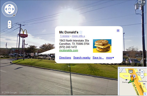
Google Maps has added clickable icons of businesses and places in Street View:

Clickable Icons in Google Maps Street View

Clickable Icons in Google Maps Street View - example of McDonald's in Carrollton, Tx

The icons are the same clickable icons found when you’re browsing maps of areas and are visible by default. When clicked, the icons pop open a little info-bubble that’s familiar as the same info-bubble boxes which appear over the standard maps view for place marks.

I’ve referred to these icons before as “landmark icons“, and these are generally going to be advantageous for businesses which have them, since they enable people browsing areas via Street View to discover them — yet another potential means of promotion.

In order to have this appear for one’s business, (more…)
Marijuana in Google Maps

Tuesday, April 20th, 2010

Today is April 20, known as “420” in pro-cannabis circles — a day in which pot-smoking is celebrated in a number of places around the United States. So, I wondered if there were any user-generated maps of 420 party locations findable in Google Maps (only out of intellectual curiosity!). While I couldn’t find any 420 parties there, I did find maps pinpointing places where one can purchase marijuana, such as this map created by HIGH TIMES Magazine:

Places To Buy Medical Marijuana In Google Maps

Of course the locations are for people interested in medical marijuana. A cursory search for places to buy illegal drugs didn’t immediately turn up anything, although I’m mildly surprised that enterprising drug sellers haven’t thought of creating custom maps in Google to promote places where people can buy it. (more…)

Google Maps Has Fixed The “Escher Effect”

Sunday, April 18th, 2010

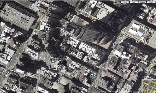
A recent quick review shows that Google Maps has cleaned up the “Escher Effect” seen in Satellite view. The Escher Effect is caused when two separate aerial or satellite pics are taken of different sections/plots of a city, and then stitched together to form a continuous composite picture. Each pic is taken from a different angle, so the taller building pictures are taken from different perspectives, causing them to appear to lean toward or away from each other.

Escher Effect of the Empire State Building, New York, NY

Escher Effect of the Empire State Building

The “Escher Effect” is named after the famous Dutch artist, M. C. Escher, who was particularly known for illustrations using optical illusions that often involved perspective and side effects from how perspective is perceived.

When Google Maps introduced satellite and aerial photos, there was a lot of the Escher Effect going on. (more…)

When Google Maps Fails

Wednesday, April 7th, 2010

This photo from Failblog illustrates a common experience for many online map users. In it, someone has posted a couple of signs stating “Dead End – Google error – Road Not Passable With Car – Google is in error…”, followed by detour instructions:

Google Maps Fail

The picture is funny, but the experience of driving somewhere wrong is not. (more…)

SepiaTown: Cool New Google Maps Mashup

Friday, April 2nd, 2010

SepiaTown - From Here To ThenSepiaTown (tagline: “From Here To Then”) is a cool Google Maps mashup that I recently ran across.

The service takes historical photos and maps them to their locations on a Google Map.

SepiaTown Example - Downtown San Francisco

The example screengrab above is from the historic Chinese Tung Food Company in downtown San Francisco, California.

The service is set up with a simple, “clean” feel, making it very easy to use.

I think that increasingly there will be instances of people taking various kinds of historical data like these vintage photograph images, and making more available through search engines and through Google Maps.

Imagine that it might be possible at some future point to click to slide some sort of tool in Google Maps which would move along a timeline, allowing one to only choose content from a particular, past timeframe.

Google Maps + Gmail = Snailmail

Wednesday, March 31st, 2010

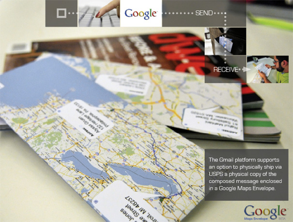
Student designers Rahul Mahtani & Yofred Moik from the Industrial Design program at Syracuse University came up with an interesting mashup. The concept is that one could write a note in Gmail, then click to have it snailmailed for a small fee. The paper envelope for the mail would be printed up with route directions from Google Maps.

Rahul Mahtani and Yofred Moik: Google Maps Snailmail Concept

Google Maps Snailmail by Rahul Mahtani and Yofred Moik

I think the concept flies a bit in the face of the trends away from print media, but there’s something compelling about the idea all the same. I like the envelopes with destination/route map images printed on them, even though I think the actual route information would be of minor-to-no-use for delivery men. And, I think there’d definitely be some market for sending snailmail notes from the Gmail interface.

(from Yanko Design)

Earth Art Collection From Google Maps

Tuesday, March 30th, 2010

Pongsocket has some fantastic satellite maps picked out as “Earth Art” from Google. Ex:

View Larger Map

Each of the aerial/satellite pictures highlights some extraordinary terrain or landscape coloration and patterns. The pictures have a wonderfully expressionistic feel to them and are well worth browsing.

However, these selections are not truly “Earth Art”, which is a name that refers to manmade constructions which fit into the natural environment in some way, rather like the works of Christo and Robert Smithson.

I’ve collected quite a bit of Earth Art examples for articles about Google Maps for a while now. Here’s Smithson’s famous “Spiral Jetty”:

Spiral Jetty by Robert Smithson

Pongsocket’s examples are some really good samples of beautiful satellite or aerial photography. But, for it to be “art”, it requires human intervention of some sort – some level of intention.