Posts Tagged ‘Google Maps’

SepiaTown: Cool New Google Maps Mashup

Friday, April 2nd, 2010

SepiaTown - From Here To ThenSepiaTown (tagline: “From Here To Then”) is a cool Google Maps mashup that I recently ran across.

The service takes historical photos and maps them to their locations on a Google Map.

SepiaTown Example - Downtown San Francisco

The example screengrab above is from the historic Chinese Tung Food Company in downtown San Francisco, California.

The service is set up with a simple, “clean” feel, making it very easy to use.

I think that increasingly there will be instances of people taking various kinds of historical data like these vintage photograph images, and making more available through search engines and through Google Maps.

Imagine that it might be possible at some future point to click to slide some sort of tool in Google Maps which would move along a timeline, allowing one to only choose content from a particular, past timeframe.

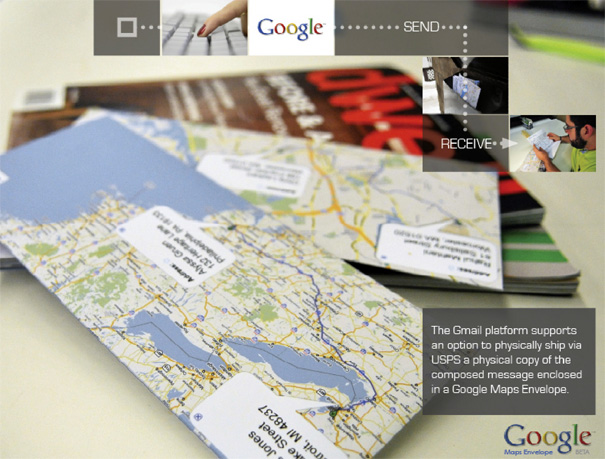
Google Maps + Gmail = Snailmail

Wednesday, March 31st, 2010

Student designers Rahul Mahtani & Yofred Moik from the Industrial Design program at Syracuse University came up with an interesting mashup. The concept is that one could write a note in Gmail, then click to have it snailmailed for a small fee. The paper envelope for the mail would be printed up with route directions from Google Maps.

Rahul Mahtani and Yofred Moik: Google Maps Snailmail Concept

Google Maps Snailmail by Rahul Mahtani and Yofred Moik

I think the concept flies a bit in the face of the trends away from print media, but there’s something compelling about the idea all the same. I like the envelopes with destination/route map images printed on them, even though I think the actual route information would be of minor-to-no-use for delivery men. And, I think there’d definitely be some market for sending snailmail notes from the Gmail interface.

(from Yanko Design)

Earth Art Collection From Google Maps

Tuesday, March 30th, 2010

Pongsocket has some fantastic satellite maps picked out as “Earth Art” from Google. Ex:

View Larger Map

Each of the aerial/satellite pictures highlights some extraordinary terrain or landscape coloration and patterns. The pictures have a wonderfully expressionistic feel to them and are well worth browsing.

However, these selections are not truly “Earth Art”, which is a name that refers to manmade constructions which fit into the natural environment in some way, rather like the works of Christo and Robert Smithson.

I’ve collected quite a bit of Earth Art examples for articles about Google Maps for a while now. Here’s Smithson’s famous “Spiral Jetty”:

Spiral Jetty by Robert Smithson

Pongsocket’s examples are some really good samples of beautiful satellite or aerial photography. But, for it to be “art”, it requires human intervention of some sort – some level of intention.

Google Maps Labs “What’s Around Here?” Feature May Reveal Ranking Factors

Friday, March 26th, 2010

Be sure to check out my new post over at SEM Clubhouse on how Google Maps Labs’ new “What’s Around Here?” feature may reveal PlaceRank secrets.

Enabling What's Around Here in Google Maps Labs

“What’s Around Here?” is a wildcard feature that allows people to view the most-popular businesses and places for a particular mapped area.

Listing out the most-popular places for any given area, without having a keyword relevance or business category factoring in as well, may allow one further insight into the relative weighting of the ranking factors that influence priority within Google Maps listings.