Archive for the ‘Maps & Mapping’ Category

NY Artist Molly Dilworth Seeks Fame Through Painting In Google Earth/Maps

Tuesday, March 29th, 2011

The Atlantic reported this past week on how one artist in New York, Molly Dilworth has been working to get her rooftop mural paintings picked up by the satellite imagery so that they may appear in Google Earth and Google Maps.

Rooftop Mural at 547 W 27th St, New York, NY, by Molly Dilworth

Rooftop Mural at 547 W 27th St, New York, NY, by Molly Dilworth. © Gil Blank 2009

The article reports how long the lagtime is between when the satellite and aerial photos in Google Earth are updated, and how she’s found it challenging to make the paintings visible enough to be seen in them. It appears to me that she’s progressively made the images with higher resolutions as she experiments with the medium.

As you may recall, I’ve reported on Earth Art that may appear in Google Maps as well as various attempts people have made to get messages and ads into the satellite pictures. Rooftop ads seem to come and go periodically (more…)

Foursquare Heat Maps

Tuesday, January 18th, 2011

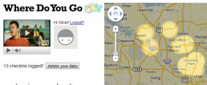
This is a pretty cool graphic interface I came across thanks to Giovanni Gallucci — it’s for checking out your Foursquare usage data: Where Do You Go. It displays your checkins using heat maps:

Where Do You Go - Foursquare Google Maps Mashup

The Google Maps mashup was built using Foursquare’s API, Python, and the Google APP Engine. I think it likely works better in Chrome or FireFox than in IE.

Creator Steven Lehrburger wrote that he created the display to graphically demonstrate to friends and acquaintances the areas which he frequents, and also as a project for a New York University mashups class he was taking.

It’s quite conceivable that Google could use similar user data in calculating personalized local search results and in figuring out the relative popularities of places within cities and neighborhoods. Google’s geolocation data for users is increasing and improving daily.

City Centroids Replaced By Outlines In Google Places

Monday, January 17th, 2011

I’ve often mentioned how Google Maps/Places has used distance from city centroids as a major ranking factor. Indeed, Google still mentions how distance is a local ranking factor (most recently they stated this in a LatLong blog post on how local search ranking works).

However, there is some compelling evidence to show that they’ve become more sophisticated than they were earlier after Google Maps was born. I believe they’re increasingly using city and ZIP code region outlines when determining the local relevancy for businesses.

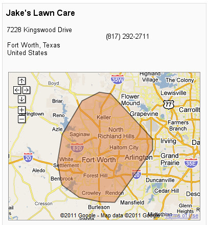
First of all, Google’s introduction of Service Areas this past year demonstrates very obviously that they’re incorporating city and ZIP region outlines with local business data. In addition to being able to specify the more traditional radius from a centroid, the tools within Google Places allow you to specify specific cities and ZIP codes as service areas, and their map indicates a rough polygon outline of selected regions. David Mihm first pointed this out to me last year, and you can see it for this example of a business which offers service to the Fort Worth area:

Google Places Service Area Polygon Outline

You can also get a business’s service area to show up outside of the Google Places administrative interfaces, in the Map interface itself, by clicking on “Show service area”: (more…)

Local Search Technology “Patent Troll” Expands Lawsuits To Target Hundreds Of Retailers

Friday, January 7th, 2011

A recent post by a member on WebmasterWorld alerted me that GeoTag is widening their local search technology lawsuits to include many more companies. WebmasterWorld sharply limits forum members from mentioning particular links, but I think the member was referring to this GeoTag Inc. v. Royal Purple Inc. et al patent suit.

GeoTag

The WebmasterWorld forum member refers to GeoTag as a “patent troll“, which I think may be deserved. He mentions that this company went after Superpages, YellowBot, Yelp, Local.com, Yellowpages.com, and many other IYPs in the past. I was aware of some of this where it concerned Superpages, but I will not comment upon that.

There has been some supposition that GeoTag might be going after relatively small targets before eventually working up to go against a major target such as Google. It’s my opinion that a number of these companies have likely settled in order to remove a nuisance or to avoid risk of an outright loss in court.

It’s also my opinion that a larger target such as a Google Maps or Bing Maps might eventually stand up to them if they were to go after them, and force a legal decision which could void out their ability to enforce this sort of claim any further. I think it may be that their claim might not have merit when considering the full scope of related prior art — although I’m certainly not an attorney. (more…)

McAfee Labs Lists Geolocation Services As Top Target For Emerging Threats In 2011

Wednesday, January 5th, 2011

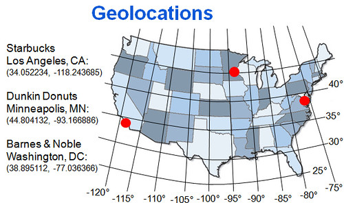
On December 28th, McAfee Labs unveiled their 2011 Threat Predictions Report, and they’ve listed Geolocation Services as one of the top targets for cybercriminal activity in 2011. Geolocation services particularly include services involving check-in activities which publish your location. Geolocation services include Facebook now, as well as Twitter, Foursquare and Gowalla.

Geolocations

From my perspective, McAfee’s inclusion of geolocation services is unsurprising and perhaps even overdue.

I wrote back in 2007 how geolocation technology is core to click-fraud detection, as well as for credit card sales, banking, and user profile verification.

Just a couple of common risks involving geolocation services involve criminals being able to use your current location information in order to victimize you. Obviously, if a criminal knows where your home is, and you’re involved in a geolocation service which is showing that you’re located in another city or across town, they could rob your home. (more…)

Sea Change: Google’s New Place Search Introduces New Disruption

Wednesday, October 27th, 2010

So, today Google began launching their new “Place Search” feature, as reported by Greg Sterling. For those of us keeping a finger on the pulse of local search marketing, the change was not a huge surprise, since we’ve been watching the testing for quite a while and could predict in advance that it might impact some online directories and small-to-medium businesses negatively.

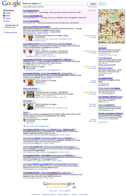
Place Search is Google’s name for the new interface and layout of local search listings within their regular keyword search results page. If you haven’t seen this yet, here’s a screengrab for “florists, los angeles, ca”:

Google Place Search - new local search layout

As you can see, the change involves the map moving into the right sidebar. The top local business listings which accompany the map are no longer to the right of the map, but are now integrated into the search results page and occupy roughly the same amount of room as the other listings. Those business listings which coordinate with the map have a lettered pink pushpin icon and some have thumbnail icons which come from their Place Page information. The big impact of the change is that these listings are now (more…)

Google Maps & Intersections

Monday, August 23rd, 2010

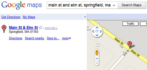
I’m not sure how many people might use this feature in Google Maps, but I suspect that relatively few people are aware that it exists. Google Maps allows one to submit more than just street addresses and city names in order to map location — they also allow you to submit intersections of cross-streets:

Google Maps & Crossroads - Main Street and Elm Street in Springfield, Massachussetts

To get a map of an intersection of two streets, you merely need to submit the request in this format: “[Street Name A] & [Street Name B], City]. In the above example, I use “main st and elm st, springfield, ma”.

Developers are probably even less aware that this feature is available in Google Maps API (more…)

The Escher Effect Invades Bing Maps

Sunday, July 11th, 2010
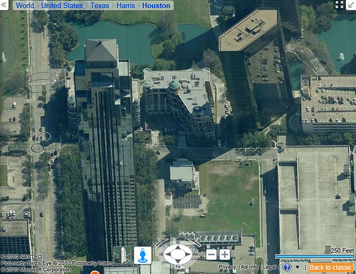
I noticed that the beta version of Bing Maps, which adds cool functionality to their mapping interface, has a fair degree of the “Escher Effect” now appearing in the Bird’s Eye view (aerial photos):
Escher Effect at the Williams Tower, Houston Tx (formerly known as Transco Tower)

Escher Effect at the Williams Tower, Houston Tx (formerly known as Transco Tower)


As you may know, the “Escher Effect” is caused by the digital stitching-together of quantities of aerial photos, some of which are taking at different times, and from different angles from one another. (more…)

The Nazi Google-Bombing In Google Maps

Friday, May 21st, 2010

Barry Schwartz pointed out on SER a Google Places Help thread about a Jewish business owner who is complaining about receiving “Nazi” keyword traffic via Google Maps. Indeed, if you search for something like “nazi” or “swastika building” in Google Maps in San Diego, this man’s Balloon business is oddly listed in the search results:
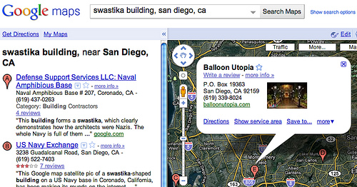
Balloon Utopia

Now, you might wonder why people would be searching for those keywords in San Diego in the first place, and there’s actually a reason why, as Barry pointed out. In fact, I feel marginally responsible for this, so I delved into the business owner’s question to try to diagnose what might be happening.

Some years back, among all the reporting and documenting I do about what’s going on in Google Maps, I came across a unique building in San Diego — an old military barracks, as it turns out, which is shaped like a Nazi Swastika:
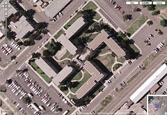
Swastika Shaped Building, Coronado Base, San Diego

I documented that in my Flickr account, and went along without thinking about it much.

Until it went viral.

At some point, some radio DJs glommed onto the story and also the Anti-Defamation League came across the picture and made the public more widely aware of the offensive shape. Even though the shape could only be seen from flying overhead or via online aerial photos, public outrage was sufficient to persuade the military to agree to renovate the exterior of the building in order to change the shape in birds-eye profile.

So, there’s reason why a lot of people are searching for “nazis” and “swastika buildings” in San Diego. But, to a lay person it may not be clear why a balloon business might come up as relevant to those searches within Google Maps.

After delving into this, I believe there’s an explanation, and a solution (more…)

Google Indexes More Place Pages… Again

Wednesday, May 5th, 2010

If you recall when Google Maps launched Place Pages last Fall, they had first represented that the pages would not be indexed to appear in Google organic search engine result pages (“SERPs”). Then, due to some “errors”, the pages actually did appear in organic results.

Now, in the last few days, I’m noticing more and more of the one-box listings appearing in organic SERPs. (more…)