Pongsocket has some fantastic satellite maps picked out as “Earth Art” from Google. Ex:
Each of the aerial/satellite pictures highlights some extraordinary terrain or landscape coloration and patterns. The pictures have a wonderfully expressionistic feel to them and are well worth browsing.
However, these selections are not truly “Earth Art”, which is a name that refers to manmade constructions which fit into the natural environment in some way, rather like the works of Christo and Robert Smithson.
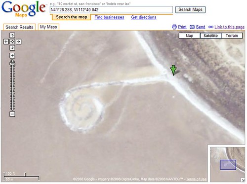
I’ve collected quite a bit of Earth Art examples for articles about Google Maps for a while now. Here’s Smithson’s famous “Spiral Jetty”:
Pongsocket’s examples are some really good samples of beautiful satellite or aerial photography. But, for it to be “art”, it requires human intervention of some sort – some level of intention.


 ShareThis
Tags: aerial images, aerial photos, Earth Art, Google Maps, Land Art, satellite images, satellite photos

[…] particularly interesting to me is that this special logo is based on earth art which is accomplished by people planting crops and arranging earthworks to depict pictures or […]
[…] you may recall, I’ve reported on Earth Art that may appear in Google Maps as well as various attempts people have made to get messages and ads into the satellite pictures. […]
[…] we’ve seen UFOs in Google Maps, illegal activites, marriage proposals, earth art, and more. Since I’ve reported on all sorts of cool things to see in Google Maps (including […]